


Circling the Puig Campana a great experienca during your hiking tours Spain
This hike around the Puigcampana in the nature reserve ‘Puigcampana y el Ponotx’ is 11 kilometres long and takes about 4 hours. There is about 600 metres of climbing and descending during this hike, with amazing views awaiting you. In the area there are several mountains with the Puigcampana the highest with it’s summit at 1406 metres above sea level. The area is famous throughout Spain for the mountain sports, such as rock climbing, that can be undertaken here.
The walk starts in the village of Finestrat at Font del Moli and from Refugio Marnes take the N-332 towards Calpe. This road is followed , passing by Benidorm and eventually take the exit marked to Finestrat. The road ascends and once arriving in the village follow the signs to ‘Font del Moli’ and then park the car.
A good idea the whole your round, hiking tours Spain!
The route of the PR-CV 289 is very well marked with yellow and white markings with two routes, one left and another going right. The left route is taken in this description.
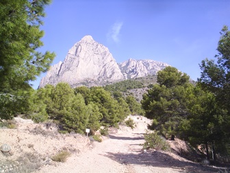 From the beginning of the route the path ascends and it will continue to do so up to a height of 987 metres above sea level. All the time the Puigcampana (photo) is on your right hand side. The views of the surroundings are beautiful as the route continues to ascends. This part of this climb is relatively open and the vegetation consists mainly of shrubs. In places it is very steep and therefore this is a tough walk for which a reasonable physical condition is needed. The top of this path is reached after about 5 km. But this is not the top of the mountain itself, and at this level more pine trees appear. To the left of this path there is a stunning view of other mountains with a valley in between which is reminiscent of mountain ranges of the Pyrenees, such gorgeous nature!
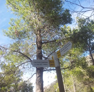 At this time there is a kind of picnic area passed, which is the Coll the Pouet. The path continues right here, which is indicated by the signs, ‘Font del Moli 6.4 kilometers’, see picture. Shortly after this intersection you can choose to go to the “Cim Puig Campana ‘, ‘Cim’ is Valencian for top of the mountain. This road is 2.1 kilometres and we have not completed this climb in the exploration of this route.
The road continues through the trees where the Mediterranean comes into view at a certain point. The ‘Font de la Solsida’ is passed and here you may see a group of Barbary sheep (Ammotragus lervia), see picture. 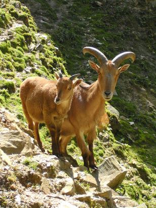 These animals rather resemble a large goat species and were introduced in Spain in 1970 for hunting and thrive very well in mountainous areas in this part of the country.
Hiking tours Spain; The descent continues with a clear view of the coastline of the Costa Blanca. This side of the mountain is bare and here it can be very warm during a sunny day. The best thing to do is to avoid the hottest part of the day, especially in summer. Hiking tours Spain, a good idea in autumn, winter and spring
Having arrived at the bottom of the path a sign indicates that it is still one kilometre to Font del Moli and this last part is walked on a asphalt road. What a fantastic walk in total silence of untouched nature so incredibly close to the hustle of the coast!
Click here for a map of the hike and details about the distance and altitude of this hike during hiking tours Spain