


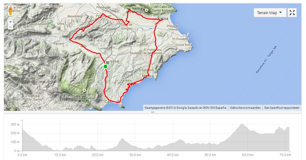
Benissa – Calpe – Moraira – Benitachell – Javea – Pedreguer – Jalon – Benissa a cycling trip Spain
 For a change try starting a cycling stage from a different point other than from your holiday location. This has the advantage of avoiding the climb back to Refugio Marnes after a tiring ride. Otherwise your finish line will always be uphill!
A flat stage of riding in mind, I drove with the bike inside the car to Benissa, parking it at the top of the village. Upon returning to the car, after a ride of over 43 miles, I realised that it is an illusion to go for a ‘flat’ round of cycling in Alicante. What they say about the Vuelta a España of “no mile is flat” also applies to the Costa Blanca. But it is beautiful scenery for cyclists who have little or no mountains in their own home environment.
Cycling trip Spain; This stage begins with a descent to Calpe from the top of the village of Benissa taking the exit ‘’Calpe sur’. Pass through the town of Calpe and when signs indicate Moraira follow this direction and the first climb starts. In Moraira you will pass by beautiful beaches taking the Teulada exit in the village. Eventually the signs indicating Benitachell (Poble Nou de Benitatxell) appear and this is the way, the CV-737, which is followed. Just before the village a traffic sign (8%) indicates that serious climbing is about to begin, and for the next 1.5 kilometers it will be an 8 or 9 % ascent. If you have turned Strava on, you can compare your performance with the professionals such as Taylor Phinney or Marco Pinotti. As previously mentioned on this website, many professional cycling teams organise training camps in this region and is the reason why the names of the professionals turn up on many Strava segments.
Cycling trip Spain; After Benitachell there is a well-deserved descent after which the road continues towards Javea. At a large roundabout, Javea (Xàbia in Valencian) is taken. Then turn left at the first major road and then left again in the direction of the village of Jesus Pobre. This is a beautiful road with the impressive cliffs of the Parc Natural del Montgo on the right hand side. In the hamlet of Jesus Pobre follow the signs towards Gata de Gorgos and once on the main road of the village take a right turn. This is the N-332 road and maintained for a short while until a traffic sign indicates ‘Pedreguer ‘, and this exit is taken. In Pedreguer head in the the direction of Alcalali. From Pedreguer the longest climb of the stage follows, peaking after the village of Llosa de Camacho at around 300 yards above sea level. The climb goes on for about 4.5 miles.
This final section, on the road between Alcalali and Xalo, it flattens in relative terms, but it is still a climb of about 1 mile towards the exit to Benissa where the car is parked.
Around 1,000 yards of altitude variation in this ‘flat’ ride; that’s cycling on your cycling trip Spain.